
North West Tasmania is a region where productive farmland, small coastal towns, dramatic headlands, beaches, rainforest and some of the island’s wildest country exist surprisingly close together.
Many travellers first encounter the region while arriving in Devonport, travelling towards Cradle Mountain or following Tasmania’s north coast west from Launceston. Yet treating North West Tasmania simply as the road between other destinations means overlooking one of the island’s most varied regions.
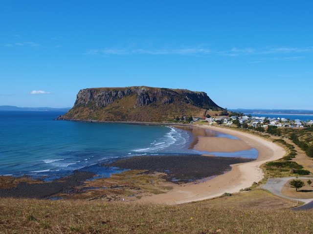
Follow the coast and the landscape changes repeatedly. Devonport provides an important gateway to the island. Ulverstone and Penguin introduce a gentler stretch of Bass Strait coastline. Burnie and Wynyard combine working towns with beaches, gardens and nearby countryside. Boat Harbour Beach sits below green hills. pinmatik/Rocky Cape National Park protects rugged coastline, heathland, geological features and places of deep Aboriginal significance. Further west, Stanley is dominated by the unmistakable profile of The Nut.
Continue beyond Stanley and North West Tasmania becomes increasingly remote. Smithton is the main service centre for the far north-west, while roads towards Arthur River and the broader takayna / Tarkine region lead into rainforest, rivers, coastal heath and a much less populated landscape.
This guide brings those places together to help you decide what to see, where to stay, how long to spend in the region and how North West Tasmania can fit into a wider Tasmanian road trip.
If you are planning the entire island rather than this region alone, begin with our Travel Tasmania guide. You can then return here when you are ready to build the North West section of your itinerary.
North West Tasmania at a Glance
- Main gateway: Devonport
- Major regional centres: Devonport, Burnie and Smithton
- Popular coastal towns: Penguin, Wynyard and Stanley
- Best-known landmark: The Nut at Stanley
- National park: pinmatik/Rocky Cape National Park
- Popular beaches: Boat Harbour Beach, Sisters Beach and beaches along the Bass Strait coast
- Wilderness direction: Arthur River and the broader takayna / Tarkine region
- Good for: road trips, small towns, coastlines, photography, food, nature, walking and slower travel
- Suggested first visit: approximately 3–5 days
- Better for deeper exploration: 5–7 days or longer
Jump to a Section
- Why Visit North West Tasmania?
- Getting to North West Tasmania
- Devonport
- Ulverstone
- Penguin
- Burnie
- Wynyard
- Table Cape
- Boat Harbour Beach
- pinmatik / Rocky Cape National Park
- Stanley
- The Nut
- Smithton
- Far North West Tasmania
- takayna / Tarkine
- Waterfalls & Rainforest
- North West Tasmania Road Trip
- Walks & Outdoor Experiences
- Food & Local Produce
- Wildlife
- Best Time to Visit
- Where to Stay
- Suggested Itineraries
- Practical Travel Tips
- Frequently Asked Questions
Why Visit North West Tasmania?
North West Tasmania does not depend on a single attraction.
Its appeal comes from the way very different landscapes and communities sit along one journey.
You can begin a morning beside a working port, stop for lunch in a small coastal town, walk above Bass Strait in the afternoon and finish the day beneath the volcanic profile of The Nut at Stanley.
Travel further west and the feeling changes again as agricultural country gradually gives way to forest, rivers, heathland and exposed coastline.
A Coast Made for Slow Road Trips
The Bass Highway provides the main east–west route through much of the region, but many of the most enjoyable places require short detours from it.
Penguin, Table Cape, Boat Harbour Beach, Sisters Beach and Stanley all reward travellers who are willing to leave the direct route rather than treating the highway as a race towards the next overnight stop.
This makes North West Tasmania particularly suitable for travellers who prefer flexible road trips.
Coast & Countryside Together
One of the region’s defining visual features is how quickly farmland can meet the sea.
Green agricultural landscapes stretch across much of the north-west, while Bass Strait remains close to the road for significant sections of the journey.
The result is a landscape that can feel quite different from the granite coastline of East Coast Tasmania or the mountain and rainforest character of West Coast Tasmania.
Small Towns with Distinct Identities
The towns are another reason to avoid rushing.
Penguin openly embraces its unusual name. Wynyard sits at the mouth of the Inglis River near Table Cape. Stanley is visually dominated by The Nut. Smithton serves a large agricultural and forestry district close to Tasmania’s far north-west.
These are not interchangeable coastal stops. Each contributes something different to the journey.
Access to Wilder Tasmania
North West Tasmania also provides one of the most practical gateways to the broader takayna / Tarkine region.
From Smithton, travellers can continue towards places such as Arthur River, forest reserves and the remote western coastline.
This makes the region especially useful for visitors who want their Tasmania trip to move gradually from accessible coastal towns into less developed country rather than jumping immediately into a remote wilderness itinerary.
Getting to North West Tasmania
How you enter North West Tasmania depends largely on whether you are arriving from mainland Australia, Launceston, Cradle Mountain or the West Coast.
Arriving Through Devonport
Devonport is one of Tasmania’s major transport gateways and is especially important for travellers arriving with their own vehicle across Bass Strait.
For these visitors, North West Tasmania can begin immediately rather than being added later in the trip.
A practical westbound sequence is:
Devonport → Ulverstone → Penguin → Burnie → Wynyard → Boat Harbour → Rocky Cape → Stanley → Smithton.
From Smithton, travellers with additional time can continue towards the far north-west and takayna / Tarkine.
From Launceston
North West Tasmania can be incorporated into a larger northern itinerary beginning in Launceston.
Rather than driving all the way to Stanley and returning in a single day, consider moving accommodation west as you travel.
Our North Tasmania guide can help you plan the section of the trip around Launceston and the northern region before continuing west.
From Cradle Mountain
Cradle Mountain and the North West Coast combine naturally in a longer itinerary.
The mountain environment provides a strong contrast with the agricultural and coastal landscapes around Devonport, Burnie, Wynyard and Stanley.
If Cradle Mountain is one of your priorities, plan that part separately with our Cradle Mountain travel guide rather than treating it as a quick North West Coast detour.
From West Coast Tasmania
Travellers coming north through western Tasmania can connect into the North West through routes around Tullah, Waratah, Burnie or the broader takayna / Tarkine country, depending on the itinerary.
Remote roads should be checked carefully before departure because surface conditions, weather and rental-vehicle restrictions may affect the route.
For the southern part of that journey, see our West Coast Tasmania Travel Guide.
Do You Need a Car?
A vehicle provides the greatest flexibility for exploring North West Tasmania.
The larger towns are connected by road and some public transport exists, but many beaches, lookouts, national-park entrances, waterfalls and wilderness areas are considerably easier to reach independently.
For a multi-day regional trip, a car or campervan generally allows a much more flexible itinerary.
Devonport: Gateway to North West Tasmania
Devonport is sometimes treated purely as an arrival or departure point, but it can be a useful first or final stop in a North West Tasmania road trip.
The city sits where the Mersey River meets Bass Strait and functions as an important regional centre.
For travellers arriving by sea with a vehicle, Devonport offers the chance to buy supplies, organise the next section of the journey and adjust to Tasmania before heading towards more rural areas.
What to Do Around Devonport
Rather than immediately leaving town, consider spending some time along the waterfront and coastal areas.
The Mersey Bluff area provides coastal views and walking opportunities, while the city itself offers cafés, shops and practical services that become less frequent as you move towards the far north-west.
Devonport can also function as a base for exploring nearby parts of the coast and inland northern Tasmania.
Should You Stay Overnight in Devonport?
It depends on your arrival time.
If your transport arrives late or you have an early departure, staying locally can be considerably more comfortable than immediately adding another substantial drive.
If you arrive with most of the day remaining, continuing towards Penguin, Burnie or Wynyard may make better use of your itinerary.
Ulverstone
West of Devonport, Ulverstone provides a relaxed introduction to the smaller towns of the North West Coast.
The town sits near the mouth of the Leven River and can work either as a brief coastal stop or as a base for exploring inland attractions.
Why Stop in Ulverstone?
Ulverstone is useful because it provides access in two directions.
Continue west and you remain on the Bass Strait coast. Turn inland and the landscape rises towards forest, farmland and destinations such as Leven Canyon.
This makes the town particularly useful for travellers who want to combine the coast with one inland nature excursion rather than following the highway continuously.
Leven Canyon
Leven Canyon is one of the better-known inland natural attractions accessible from this part of North West Tasmania.
The canyon provides a dramatic contrast with the low coastal country around Ulverstone, with forest and steep terrain surrounding the Leven River.
Allow more time than the direct driving distance suggests because this is an inland detour rather than a quick roadside lookout on the Bass Highway.
Penguin
Penguin is one of Tasmania’s most memorably named towns and one of the easiest places to add to a North West Coast road trip.
The town sits directly beside Bass Strait between Ulverstone and Burnie and has built part of its identity around the little penguins associated with this coastline.
Its best-known landmark is the Big Penguin on the foreshore, but the town is more than a photograph beside an oversized statue.
Things to Do in Penguin
- Walk along the waterfront.
- See the Big Penguin.
- Explore the small town centre.
- Stop for food or coffee during a coastal drive.
- Use Penguin as a relaxed break between Ulverstone and Burnie.
Penguin does not require an entire day for most first-time visitors. Its value is as a pleasant coastal town where slowing down for an hour or two can improve the overall road trip.
Burnie
Burnie is one of the North West Coast’s main regional centres.
Its history and identity have long been connected with industry and the port, but the city also provides access to coastal areas, food producers, surrounding farmland and inland nature destinations.
For travellers, Burnie’s practical value should not be overlooked. It provides supermarkets, fuel, accommodation and other services before the journey continues towards Wynyard, Stanley and the less populated far north-west.
How Long Do You Need in Burnie?
A few hours may be enough if Burnie is one stop on a coastal road trip.
Staying overnight makes more sense when you want to explore nearby inland areas, use the city as a service base or avoid packing too many towns into a single day.
Wynyard
Wynyard sits near the mouth of the Inglis River and is one of the most useful bases for exploring the central section of Tasmania’s North West Coast.
The town itself has a relaxed coastal character, while Table Cape rises prominently just to the west.
From Wynyard, travellers can reach Table Cape, Boat Harbour Beach and several inland waterfalls and forest areas without needing to relocate accommodation every night.
Why Stay in Wynyard?
Wynyard works well for travellers who prefer a central base rather than changing hotels between Burnie and Stanley.
It is close enough to several major North West attractions to make day trips practical while still providing everyday services.
Table Cape
Table Cape is one of the North West Coast’s most distinctive landforms.
The elevated headland rises above Bass Strait near Wynyard, creating broad coastal and agricultural views.
The contrast between the flat-topped headland, surrounding farmland and sea makes this part of the coast particularly attractive for scenic driving and photography.
Table Cape in Spring
Spring is especially associated with flowering farmland around Table Cape, including the area’s well-known tulip displays.
Seasonal flowering depends on timing and agricultural conditions, so travellers visiting specifically for flowers should check current opening dates and flowering information rather than assuming the same peak period every year.
Table Cape Lighthouse
The lighthouse adds another visual landmark to the headland and the surrounding roads provide several opportunities to appreciate the elevated coastline.
Strong winds are possible on exposed sections, so bring an outer layer even when conditions feel mild in Wynyard.
Boat Harbour Beach
Boat Harbour Beach is one of the North West Coast’s most attractive beach stops.
The small bay sits below green hills and provides a different coastal atmosphere from the exposed headlands found further west.
On a calm, clear day the water can appear strikingly bright, while the surrounding slopes create a sheltered visual setting.
What to Do at Boat Harbour Beach
- Walk along the beach.
- Enjoy the coastal scenery.
- Stop for a relaxed break between Wynyard and Rocky Cape.
- Swim when conditions are appropriate for your ability.
- Use the area as part of a broader coastal day including Sisters Beach and Rocky Cape.
As with beaches anywhere in Tasmania, conditions can change. Assess weather, water and local safety information before swimming.
pinmatik / Rocky Cape National Park
pinmatik / Rocky Cape National Park is one of the most important natural and cultural landscapes on Tasmania’s North West Coast.
The national park lies between the Boat Harbour–Sisters Beach area and Stanley and protects rugged Bass Strait coastline, coastal heath, ancient rock formations, caves, secluded bays and places of profound significance to Tasmanian Aboriginal people.
Tasmania Parks and Wildlife Service notes that some of the rocks at Rocky Cape are among Tasmania’s oldest. Precambrian quartzite has been uplifted, folded and gradually shaped by wind and water into the coastline visible today.
The park also contains rock shelters and caves associated with thousands of years of Aboriginal occupation. Visitors should respect interpretive guidance and must not enter culturally sensitive caves where signs request that people remain outside.
Do You Need a Parks Pass?
Yes. pinmatik / Rocky Cape is a Tasmanian national park and a valid parks pass is required for entry.
Walking at Rocky Cape
Rocky Cape is particularly rewarding on foot.
Current Tasmania Parks and Wildlife Service information lists walks ranging from approximately 20 minutes to four hours, with routes extending from short cave and lighthouse walks to longer inland and coastal tracks.
Shorter options include the North Cave and Lighthouse area and the South Cave track. Longer routes explore heath-covered hills, rocky coastline, bays and the Sisters Beach side of the national park.
North Cave & Lighthouse
Parks currently lists the North Cave and Lighthouse walk at approximately 600 metres return and around 10–20 minutes.
The route passes through coastal heath towards a viewing area near a cave formerly used as an Aboriginal shelter. Visitors are asked not to enter the cave.
Banksia Grove & Caves Circuit
From the Sisters Beach side, the Banksia Grove area provides an opportunity to experience a different part of the park.
The landscape includes coastal heath and an unusual stand of saw banksia. Parks notes that this species is restricted to a small part of Tasmania even though it is more widespread on mainland Australia.
Longer Walks
More experienced walkers can consider longer inland or coastal routes between the Rocky Cape and Sisters Beach areas.
Parks currently lists the Inland Track at approximately 15 kilometres one way and around 3.5–4 hours, with additional side trips available.
These longer routes require more planning than the short cave walks. Weather can change, sections may be rough, and transport needs to be organised if completing a one-way route.
Respecting Rocky Cape
Rocky Cape is not simply a scenic coastal park.
The cultural significance of the caves, middens and landscape deserves the same attention as the views. Follow signs, remain on designated tracks and avoid entering caves where requested.
Parks also advises visitors that the plant disease Phytophthora is present in the national park. Cleaning soil from footwear when leaving helps reduce the risk of spreading it to other areas.
Stanley
Stanley is one of North West Tasmania’s most recognisable towns.
The historic settlement sits beneath The Nut, a huge flat-topped volcanic landform rising abruptly beside Bass Strait.
Its setting is unusual enough that Stanley can feel visually distinct before you have even parked the car.
For many travellers, Stanley becomes the natural destination at the end of a North West Coast road trip from Devonport. But it is worth allowing enough time to explore rather than simply photographing The Nut and immediately turning back east.
Things to Do in Stanley
- Walk or take the chairlift to The Nut.
- Complete the summit circuit.
- Explore Stanley’s historic streets.
- Walk around the waterfront.
- Visit coastal viewpoints.
- Stay overnight and experience the town after day visitors leave.
- Use Stanley as a base for exploring the far north-west.
How Long Should You Spend in Stanley?
A half-day can cover the main sights, but one night is much better if your itinerary allows it.
Two nights can work well when Stanley is being used as a base for exploring Smithton, Dip Falls, Arthur River or other parts of the far north-west.
The Nut at Stanley
The Nut is Stanley’s defining landmark and one of the most recognisable geological features in northern Tasmania.
Tasmania Parks and Wildlife Service describes The Nut as the core of a long-extinct volcano. Its steep sides and broad summit rise directly beside the town, creating panoramic views across Stanley, Bass Strait and towards Rocky Cape.
Walking to the Summit
Visitors can reach the summit on foot via the steep walking route.
The initial climb is short but demanding for some visitors because of its gradient. Once on the plateau, the summit circuit provides a much gentler way to explore the top and its viewpoints.
The Nut Chairlift
A chairlift provides another way to reach the summit when operating.
Operating schedules can be affected by weather, maintenance and seasonal arrangements, so check current information rather than assuming the chairlift will operate on every visit.
Weather on The Nut
The summit is exposed to Bass Strait weather.
Conditions can feel considerably cooler and windier than they do in the streets below. Carry a suitable outer layer even when Stanley itself feels comfortable.
Smithton
Smithton is the main service town for Tasmania’s far north-west and plays a different role from Stanley.
Where Stanley is strongly visitor-oriented and visually defined by The Nut, Smithton functions as a working regional centre surrounded by productive agricultural country.
For travellers, Smithton is particularly useful as a place to refuel, buy supplies and prepare before heading towards more remote areas.
Should You Stay in Smithton or Stanley?
For a first leisure visit, Stanley generally provides the more distinctive overnight experience.
Smithton may be more practical if your priority is travelling further west or if accommodation availability and your route make it more convenient.
Because the towns are relatively close, they can easily form part of the same regional itinerary.
Far North West Tasmania
Beyond Stanley and Smithton, the character of North West Tasmania begins to change noticeably.
Settlements become smaller, services become less frequent and the landscape increasingly feels shaped by wind, ocean, forest and distance.
This part of Tasmania deserves more preparation than the main Bass Highway corridor.
Arthur River
Arthur River is a small settlement near the mouth of the Arthur River on Tasmania’s remote western side.
The area provides access to river, forest and exposed coastal landscapes and is commonly incorporated into journeys through the broader takayna / Tarkine region.
Visitors should arrive prepared for fewer services than they would find around Devonport, Burnie or Stanley.
The Edge of the World
Near Arthur River, the coastline opens directly towards the Southern Ocean.
A lookout popularly known as the Edge of the World has become one of the far north-west’s best-known stops.
The appeal is less about a conventional attraction and more about the feeling of exposure: ocean, wind, driftwood and a sparsely developed coastline stretching away from the settlement.
Weather can be powerful here. Remain behind barriers where provided and avoid approaching dangerous water or exposed rocks for photographs.
Exploring takayna / Tarkine from North West Tasmania
The broader area commonly known as takayna / the Tarkine is one of Tasmania’s most remarkable large-scale landscapes.
It includes extensive rainforest, rivers, buttongrass country, coastal heath, wetlands and wild coastline across north-western Tasmania.
It is important not to describe the entire Tarkine as one national park. The name refers to a much broader region containing different land tenures and reserves.
For travellers based in Stanley or Smithton, the northern Tarkine touring routes can provide an accessible introduction to the region without immediately committing to remote multi-day wilderness travel.
What Makes the Tarkine Different?
The change from North West Tasmania’s open agricultural country into dense forest can be surprisingly abrupt.
Roads enter landscapes where tall forest, fern-filled gullies, rivers and wetlands replace the broad coastal farmland seen around Wynyard and Stanley.
Closer to the western coast, the environment changes again into exposed heath, dunes and Southern Ocean coastline.
Tarkine Drive
The Tarkine Drive is not simply one attraction. It is a touring route connecting multiple forest, river and coastal stops.
This is why allocating a full day—or longer—usually works better than attempting to squeeze the region between Stanley and another distant destination.
Potential stops can include rainforest walks, river viewpoints, geological formations and coastal areas, depending on current road and track conditions.
Trowutta Arch
Trowutta Arch is one of the better-known natural features in the northern Tarkine area.
The short forest approach leads to a striking geological formation surrounded by dense vegetation.
Conditions can be damp and slippery after rain, so suitable footwear is useful even though the visit is relatively short.
Allow Time for the Forest
The Tarkine is easy to underestimate because many individual stops appear close together on a map.
Forest roads, photography stops, short walks and changing conditions all add time.
A better approach is to select a smaller number of stops and experience them properly rather than attempting every marked attraction in one day.
Waterfalls & Rainforest in North West Tasmania
The coastline receives much of the attention, but some of North West Tasmania’s strongest natural experiences sit inland.
Rainforest, rivers and waterfalls provide an effective contrast with the open agricultural country near the Bass Strait coast.
Dip Falls
Dip Falls is one of the best-known waterfall stops in the far north-west and can be incorporated into a Stanley or Smithton-based day trip.
The waterfall is particularly distinctive because water drops across unusual stepped rock formations.
Waterfall appearance varies with recent rainfall, so photographs taken after heavy rain should not be treated as a guarantee of identical conditions throughout the year.
Why Inland Detours Matter
A North West Tasmania itinerary consisting only of the Bass Highway can create the impression that the region is mostly farmland and seaside towns.
Driving inland reveals a much broader landscape.
Forest, rivers, waterfalls and valleys help explain how the North West Coast transitions into Tasmania’s wetter western wilderness.
North West Tasmania Road Trip
North West Tasmania is particularly well suited to road travel because many of its towns and attractions form a logical east-to-west sequence.
A straightforward coastal route is:
Devonport → Ulverstone → Penguin → Burnie → Wynyard → Table Cape → Boat Harbour Beach → pinmatik/Rocky Cape → Stanley → Smithton.
Travellers with additional time can then extend towards:
Dip Falls → Trowutta → Arthur River → takayna / Tarkine.
Do Not Try to Stop Everywhere in One Day
The individual distances can make this route look deceptively easy.
However, once you add town walks, beaches, lunch, national-park walks, lookouts and photography, a one-day dash from Devonport to Stanley can become much busier than expected.
Two or three coastal days produce a more enjoyable trip.
Where Should You Break the Journey?
Wynyard provides a useful intermediate base.
Stanley is the strongest choice further west for travellers who want to experience the town and The Nut outside the busiest part of the day.
For a longer itinerary, adding another night around Stanley, Smithton or the far north-west allows the Tarkine section to be explored without rushing.
Once your route is settled, you can compare accommodation options for your Tasmania road trip. It is usually more useful to choose accommodation according to the following day’s route than simply selecting the lowest price in a distant town.
Affiliate note: Some links in this guide are affiliate links. If you make an eligible booking or purchase through one of these links, Island Files Tasmania may receive a commission at no additional cost to you. This helps support the ongoing creation and maintenance of independent Tasmania travel content.
Walks & Outdoor Experiences in North West Tasmania
North West Tasmania offers a useful mix of short coastal walks, national-park tracks, forest walks and longer outdoor experiences. The region is especially appealing for travellers who want varied scenery without committing every day to a major mountain hike.
Some walks are brief enough to fit between towns, while others deserve several hours and more careful planning. Weather, track condition and fitness should determine which route is appropriate on the day.
pinmatik / Rocky Cape National Park Walks
Rocky Cape is one of the strongest walking destinations in the region because several routes begin from different sections of the park.
Short walks around cave and lighthouse areas suit travellers with limited time, while longer routes connect coastal heath, hills and beaches between Rocky Cape and Sisters Beach.
When choosing a route, remember that exposed heathland can feel very different from sheltered forest. Wind, sun and changing weather may affect comfort even when the distance appears modest.
The Nut Summit Circuit
The Nut at Stanley provides one of the region’s most recognisable short walks.
The steep climb to the summit can feel challenging for some visitors, but once on top the circuit is much gentler and offers broad views over Stanley, Bass Strait and surrounding farmland.
Strong wind is common on exposed headlands, so a jacket can be useful even on an otherwise mild day.
Boat Harbour and Sisters Beach
Boat Harbour Beach and Sisters Beach provide simple coastal walking opportunities without requiring a formal hiking plan.
They work especially well on a day already containing a longer walk at Rocky Cape because they give visitors time beside the coast without adding another demanding activity.
Leven Canyon
Leven Canyon provides a more dramatic inland environment than the Bass Strait coast.
Forest, steep terrain and elevated views make the canyon a useful choice for travellers wanting to see another side of North West Tasmania.
Allow enough driving time for the inland detour and check current track information before travelling, particularly after periods of severe weather.
Trowutta Arch
Trowutta Arch is one of the more accessible forest experiences in the far north-west.
The short walk passes through dense vegetation before reaching a striking natural arch and sinkhole landscape.
The forest floor can be wet and slippery, so footwear with suitable grip is recommended even though the route itself is not long.
Choosing the Right Walk
- For short coastal scenery: The Nut summit area, Boat Harbour Beach or Sisters Beach.
- For national-park walking: pinmatik / Rocky Cape National Park.
- For inland forest and canyon scenery: Leven Canyon.
- For a short rainforest experience: Trowutta Arch.
- For a relaxed day: combine one short walk with a beach or town rather than scheduling several hikes.
Food & Local Produce in North West Tasmania
North West Tasmania is one of the island’s major agricultural regions, and food is closely connected with the surrounding landscape.
Rich soils, dairy farming, vegetable production, beef cattle, seafood and cool-climate conditions all contribute to the region’s food identity.
Travellers interested in local produce can easily build food stops into a road trip without making food the only focus of the journey.
Dairy and Cheese
The north-west has a strong dairy tradition, and cheese, milk and other dairy products are closely associated with the region.
Some producers offer visitor experiences or direct sales, but opening days and access can change. If visiting a particular producer matters to you, check current information before making a detour.
Seafood
Coastal towns and working ports provide access to Tasmanian seafood, although availability depends on season, supply and individual businesses.
Stanley is particularly well placed for travellers wanting to combine coastal scenery with seafood-focused dining.
Fresh Produce
The farmland around Devonport, Burnie, Wynyard and Smithton supports a wide range of produce.
Roadside stalls and small producers may appear along regional routes, although availability is seasonal and should not be treated as guaranteed.
Food Stops as Part of the Road Trip
One of the easiest ways to experience North West Tasmania is to combine food with the geography of the day.
A coastal morning around Wynyard can be followed by lunch in town, a beach stop at Boat Harbour and an afternoon around Rocky Cape. Another day might combine Stanley with local produce and a drive towards Smithton.
Keeping food stops flexible also avoids disappointment when smaller businesses operate limited days or seasonal hours.
Wildlife in North West Tasmania
North West Tasmania supports wildlife across coastal, farmland, forest, wetland and national-park environments.
Visitors may encounter wallabies, pademelons, possums, wombats, seabirds and a wide range of other native species, although sightings are never guaranteed.
Little Penguins
Little penguins occur along parts of Tasmania’s north coast, including around towns such as Penguin.
Responsible viewing is important. Avoid flash photography, bright lights and approaching birds closely. Do not block their movement between the sea and nesting areas.
Seabirds and Shorebirds
Beaches, rocky headlands and estuaries support a range of seabirds and shorebirds.
Some species nest directly on or near beaches, so visitors should respect seasonal signs, fenced areas and local access restrictions.
Wildlife in the Far North West
As the landscape becomes less developed towards Arthur River and the broader takayna / Tarkine region, the chance of encountering native wildlife around roads and campgrounds also increases.
Do not feed animals, and keep food secured when camping.
Wildlife and Driving
Wildlife is especially active around dawn, dusk and at night.
Where possible, organise the itinerary so that long rural drives are completed in daylight.
If night driving cannot be avoided, reduce speed and remain alert for animals entering the road unexpectedly.
Best Time to Visit North West Tasmania
North West Tasmania can be explored throughout the year, but the experience changes significantly with the seasons.
Summer: December to February
Summer offers long daylight hours and generally milder conditions, making it popular for road trips, beaches, national-park walks and extended sightseeing days.
It is also one of the busier periods, especially around Stanley, coastal accommodation and major holiday dates.
Do not assume every day will be warm and calm. Bass Strait weather can remain windy and changeable even during summer.
Autumn: March to May
Autumn can be especially pleasant for road trips and walking.
The busiest summer period generally begins to ease, while daylight remains useful for longer regional drives early in the season.
Winter: June to August
Winter provides a quieter version of North West Tasmania.
Beaches, small towns, food, photography and forest experiences remain worthwhile, but shorter daylight and wet weather require more flexible planning.
Inland roads can be colder than the coast, and mountain routes elsewhere in northern Tasmania may experience frost, ice or snow.
Spring: September to November
Spring is one of the most visually interesting periods in the region.
Table Cape is especially associated with seasonal flower displays, while farmland and gardens across the North West become increasingly colourful.
Weather remains changeable, so carry layers and a waterproof outer layer.
Which Season Is Best?
There is no single best season for every visitor.
- For beaches and long daylight: summer.
- For comfortable road trips: autumn or spring.
- For seasonal flowers: spring.
- For quieter towns and moody coastlines: winter.
Where to Stay in North West Tasmania
The best accommodation strategy depends on how far west you intend to travel.
Trying to use Devonport as the base for the entire region can create unnecessary driving, especially if Stanley, Smithton and the far north-west are priorities.
Devonport
Devonport works well for arrivals, departures and the eastern part of the region.
It is also useful for travellers connecting with northern Tasmania or Cradle Mountain.
Burnie
Burnie provides a practical central service base with easy road access east and west.
Wynyard
Wynyard is one of the strongest choices for travellers wanting a quieter coastal base with access to Table Cape, Boat Harbour Beach and Stanley.
Stanley
Stanley is the most distinctive overnight stop for many visitors.
Staying locally allows time to explore The Nut and the town outside the busiest middle part of the day.
Smithton
Smithton can be more practical for travellers heading deeper into the far north-west or the Tarkine.
Once your travel dates are clear, you can compare accommodation across North West Tasmania. Choose accommodation according to your next day’s route as well as price.
Camping & Campervan Travel in North West Tasmania
North West Tasmania works well for campervan and camping trips because the region contains a mix of caravan parks, campgrounds and more remote touring routes.
However, freedom to travel does not mean freedom to camp anywhere.
Use legal camping areas and confirm current council, national-park and reserve requirements before staying overnight.
Remote routes towards Arthur River and the Tarkine require more self-sufficiency than the main coastal corridor.
Travellers planning a wider camping trip around Tasmania may find an Australian camping and road-trip guide useful for researching legal overnight stops. Always verify the current status with the relevant land manager before staying.
Mobile Coverage, Fuel & Services
Practical planning becomes increasingly important as you travel west from Stanley and Smithton.
Mobile Coverage
Mobile reception is generally stronger in and around the larger towns than in remote forest, national-park and coastal areas.
Download offline maps and save booking details before heading into less populated areas.
International visitors who want mobile data can check eSIM options for Australia before travelling. An eSIM does not remove physical network black spots, so offline navigation remains useful.
Fuel
Fuel is readily available in the main towns, but service frequency reduces in remote areas.
Do not allow the tank to become unnecessarily low before travelling into the far north-west.
Food & Supplies
Devonport, Burnie, Wynyard and Smithton provide useful places to stock up.
Carry adequate food and water before longer remote drives rather than assuming every small settlement will have a supermarket or café open when you arrive.
Suggested North West Tasmania Itineraries
The region can be experienced in two or three days, but five days is a much better introduction. Seven days allows the far north-west and the Tarkine to be included without turning each day into a long drive.
3-Day North West Tasmania Itinerary
- Day 1 – Devonport to Wynyard: Stop in Ulverstone, Penguin and Burnie before exploring Wynyard and Table Cape.
- Day 2 – Wynyard to Stanley: Visit Boat Harbour Beach and pinmatik/Rocky Cape National Park before continuing to Stanley.
- Day 3 – Stanley: Explore The Nut and Stanley before continuing towards your next region.
This itinerary provides a strong coastal introduction but leaves very little time for Smithton or the Tarkine.
5-Day North West Tasmania Itinerary
- Day 1 – Devonport and Ulverstone: Explore the eastern North West Coast and stay around Ulverstone or Penguin.
- Day 2 – Penguin, Burnie and Wynyard: Travel slowly along the coast and explore Table Cape.
- Day 3 – Boat Harbour and Rocky Cape: Spend time at Boat Harbour Beach and complete one or more walks at pinmatik/Rocky Cape National Park.
- Day 4 – Stanley: Explore The Nut, town streets and coastal areas.
- Day 5 – Smithton and the far north-west: Continue towards Smithton, Dip Falls, Trowutta or another selected far north-west destination.
7-Day North West Tasmania Itinerary
- Day 1 – Devonport: Arrive, explore the waterfront and settle into the region.
- Day 2 – Ulverstone and Penguin: Explore coastal towns or add Leven Canyon.
- Day 3 – Burnie, Wynyard and Table Cape: Continue west with time for scenic stops.
- Day 4 – Boat Harbour and Rocky Cape: Spend a full day on beaches and national-park walks.
- Day 5 – Stanley: Explore The Nut and stay locally.
- Day 6 – Smithton, Dip Falls and Trowutta: Move into the far north-west.
- Day 7 – Arthur River or Tarkine: Explore a selected part of the remote north-west before continuing south or returning east.
North West Tasmania and Cradle Mountain
North West Tasmania combines naturally with Cradle Mountain.
A practical route can follow:
Devonport → North West Coast → Stanley → Smithton → return east or south → Cradle Mountain.
Alternatively, visit Cradle Mountain first and then continue north towards Devonport, Burnie and Stanley.
North West Tasmania and West Coast Tasmania
The region also connects with West Coast Tasmania.
A longer route can move through the Tarkine or inland road corridors towards Rosebery, Zeehan and Strahan.
Remote sections should be checked carefully before departure because road surfaces, weather and ferry arrangements can affect the route.
Planning Flights and Car Hire
If you are flying into Tasmania, Launceston is often a practical northern gateway, while Devonport is especially important for travellers arriving by sea.
You can compare flights to Tasmania before deciding which arrival point works best for your road trip.
If you need a vehicle, you can also compare car rental options in Tasmania. Check one-way fees, road restrictions and insurance before booking.
Practical North West Tasmania Travel Tips
1. Do Not Rush from Devonport to Stanley
The coastline between them contains enough towns, beaches and detours to justify several days.
2. Use Wynyard as a Strategic Base
Wynyard is well positioned for Table Cape, Boat Harbour and the next stage towards Rocky Cape and Stanley.
3. Stay in Stanley if You Can
One night allows you to experience the town and The Nut outside the busiest part of the day.
4. Treat the Far North West Separately
Arthur River, Tarkine drives and forest routes require more time and preparation than the main coastal highway.
5. Carry Layers
Bass Strait wind can make exposed headlands feel much cooler than sheltered towns.
6. Check National Park Requirements
A valid Tasmania parks pass is required for pinmatik / Rocky Cape National Park.
7. Respect Aboriginal Cultural Sites
Rock shelters, caves and middens at Rocky Cape and elsewhere are culturally significant. Follow signs, remain on established tracks and leave cultural material undisturbed.
8. Download Offline Maps
This becomes increasingly useful west of Smithton and on forest touring roads.
9. Avoid Unnecessary Night Driving
Wildlife can move onto rural roads around dawn, dusk and at night.
10. Do Not Depend on Every Small Business Being Open
Carry fuel, food and water appropriate for your route, especially in the far north-west.
Frequently Asked Questions About North West Tasmania
How many days do you need in North West Tasmania?
Three days provides a basic coastal introduction. Five days is better for including Rocky Cape, Stanley and Smithton. Seven days allows the far north-west and parts of the Tarkine to be explored at a more relaxed pace.
Is North West Tasmania worth visiting?
Yes. The region combines coastal towns, beaches, farmland, national parks, Stanley, The Nut and access to the far north-west and takayna / Tarkine.
What are the main towns in North West Tasmania?
For visitor planning, the main towns include Devonport, Ulverstone, Penguin, Burnie, Wynyard, Stanley and Smithton.
What is the best town to stay in?
There is no single best base for the entire region. Devonport is practical for arrivals, Wynyard works well for the central coast, and Stanley is the most distinctive western overnight stop for many first-time visitors.
Is Stanley worth visiting?
Yes. Stanley is one of the most distinctive towns in North West Tasmania and is dominated by The Nut, a large extinct volcanic feature beside Bass Strait.
How long should you spend in Stanley?
A half-day covers the main sights, but one night provides a much more relaxed experience. Two nights can work well if Stanley is being used as a base for Smithton and the far north-west.
Can you walk up The Nut?
Yes. A steep walking route reaches the summit. A chairlift also operates at selected times, subject to weather and operating arrangements.
Is The Nut an extinct volcano?
Tasmania Parks and Wildlife Service describes The Nut as the core of a long-extinct volcano.
Do you need a parks pass for Rocky Cape?
Yes. pinmatik / Rocky Cape is a Tasmanian national park and requires a valid parks pass.
Is Rocky Cape worth visiting?
Yes, especially for travellers interested in coastal walking, geology and Aboriginal cultural heritage. The park offers both short and longer walking options.
Is Boat Harbour Beach worth visiting?
Boat Harbour Beach makes an excellent coastal stop between Wynyard and Rocky Cape and combines easily with Sisters Beach and Stanley.
Is Penguin worth stopping in?
Yes. Penguin is a relaxed waterfront town that works well as a short stop between Ulverstone and Burnie. The Big Penguin is the best-known landmark, but the waterfront itself is also worth exploring.
What is Table Cape known for?
Table Cape is known for its elevated coastal views, farmland, lighthouse and seasonal spring flower displays.
What is the Tarkine?
takayna / the Tarkine refers to a broad region of north-western Tasmania containing rainforest, rivers, wetlands, buttongrass plains, coastal heath and wild coastline. It is not one single national park.
Can you visit the Tarkine from Stanley?
Yes. Stanley and Smithton can both work as bases for day trips into selected northern parts of the Tarkine, although longer routes may benefit from an additional overnight stay closer to the area.
Is Arthur River worth visiting?
Arthur River is worthwhile for travellers interested in remote coastline, river scenery and the broader Tarkine region. It requires more time than a normal Stanley sightseeing day.
Can you combine North West Tasmania and Cradle Mountain?
Yes. Cradle Mountain and North West Tasmania combine naturally in a multi-day northern itinerary. Use our Cradle Mountain guide to plan the mountain section separately.
Can you combine North West Tasmania with the West Coast?
Yes. The regions connect through inland and western routes, especially for longer road trips incorporating the Tarkine, Rosebery, Zeehan and Strahan.
Do you need a 4WD for North West Tasmania?
No. A conventional vehicle is suitable for the main towns, highways and many major attractions. Some remote or unsealed roads require additional care, and rental-car conditions should always be checked.
Can you visit North West Tasmania in winter?
Yes. Winter is quieter and can be excellent for coastal scenery, food and photography. Shorter daylight and wetter conditions require a more flexible itinerary.
When is the best time to visit North West Tasmania?
The region can be visited year-round. Summer provides longer days and beach weather, autumn suits road trips, spring is attractive for flowers and gardens, and winter offers quieter travel.
Is North West Tasmania suitable for families?
Yes. Beaches, small towns, short walks, Stanley and scenic drives provide many family-friendly options. Choose national-park walks according to children’s ability and supervise closely around cliffs, beaches and roads.
Explore North West Tasmania at a Slower Pace
North West Tasmania is easy to underestimate because many of its best-known places sit along a relatively straightforward road corridor.
But the region changes significantly as you travel west.
Devonport feels like a gateway. Penguin is small and playful. Burnie and Wynyard provide practical coastal bases. Table Cape rises above farmland. Boat Harbour brings the road back to the beach. Rocky Cape introduces a deeper natural and cultural landscape. Stanley is dominated by one of Tasmania’s most distinctive landforms. Beyond Smithton, the journey begins to feel increasingly remote.
The strongest North West Tasmania itinerary therefore does not try to compress all of these places into one long day.
Allow time for one beach to become more than a photograph, one town to become more than a fuel stop and one national park to become more than a pin on the map.
If you are continuing south, use our West Coast Tasmania Travel Guide. If you are heading towards the mountains, continue with our Cradle Mountain guide. For northern connections, use our North Tasmania Travel Guide.
For the full island-wide picture, return to our Travel Tasmania pillar guide. If you are still deciding how many days to spend in each region, use our complete Tasmania trip planning guide.
Planning note: Road conditions, national park requirements, track access, ferry or transport arrangements, campground rules, business opening hours and weather can change. Check current information from the relevant authority or operator before travelling, especially when entering remote parts of the far north-west or undertaking longer national-park walks.